Announcement

Collapse
No announcement yet.

Tesla's wireless electricity transmission

Collapse
X
 
  • Filter
  • Time
  • Show
Clear All
new posts

  • It's funny how you can find interesting tidbits in most unlikely places:

    YouTube - Psychic intuitive on why Tunguska event occurred

    Draw conclusions based on your own belief system...
    Are the ravings of a lunatic signs of a genius?

    Comment


    • Some other food for thought:

      Google

      Comment


      • Tunguska Event

        Hi Altair, amigo, all members and guests,

        The Tunguska incident Tunguska event - Wikipedia, the free encyclopedia ( 60 55' 00"N, 101 57' 00"E ) is one that is clouded with mystery and intrigue leaving many questions some that can be answered and some that may never be. At the time in 1908 when the first reference to the "peace ray" which later became the death ray by the media covering Tesla's research, little is known of the weapons construction other than several verifiable reports that one existed and had been used. So let us now jump to the 1930's early 1940's to what we know about the "Teleforce" or peace ray weapon Teleforce - Wikipedia, the free encyclopedia , the best description was explained by Tesla published in the "New York Times" September 22, 1940

        Tesla's 'Death Ray' In 1940 NY Times

        If we use the same principles for the 1908 proposed experimentation from the Wardenclyffe laboratory ( 40 56' 50.30"N, 72 53' 55.60"W ) with mercury as a projectile this is what we have. The element is derived from the mineral ore "cinnabar" Cinnabar - Wikipedia, the free encyclopedia by crushing the ore and heating a vapor appears containing cyanide and mercury the vapor condenses gasses removed and the element of liquid mercury Mercury (element) - Wikipedia, the free encyclopedia is left.

        Mercury was the base matter because it is one of only several elements that electricity would ball around it, conductive in a vapor or liquid under pressure or in a vacuum, mercury also has heavy ion's, Its zero oxidation state exists as vapor or as liquid metal. It is used in lighting; electricity passed through mercury vapor in a pressurized phosphor tube produces short-wave ultraviolet light which then causes the phosphor to fluoresce, making visible light. Mercury was a propellant for early ion engines in electric propulsion systems and some electrostatic accelerators, and the most important mercury has "Diamagnetism" Diamagnetism - Wikipedia, the free encyclopedia properties which could be accomplished through a high voltage "Tesla" coil or a "Van de Graaff" generator arrangement.

        The illustrations from "Nikola Tesla's Teleforce & Telegeodynamics" Proposals Tesla's Death Ray was quite a change from the most powerful weapon in the United States arsenal, a 16" (inch) cannon about 70' (feet) long weighing 120 tons that could fire a 2,700 lbs. (pound) shell or projectile about 24 miles in distance. This proposed weapon of Nikola Tesla was said to be able to send it's projectile hundreds of miles to a target, his new technology somewhat looks totally sientifically possible given the materials and parameters of construction. There is only several problems I see that were not detailed but there existence cannot be denied, the first is the ultra violet beam that has a visibility problem which could be easily overcame and the second is the small size. The size of the actual weapon itself compaired to others has one great advantage weight, but the weapons length is a biggie anyone who has shot a hand gun and a rifle knows what I'm saying here .... the longer the barrel the more accurate the shot.

        When Tesla tried to signal the expedition at the North pole several thousand miles away from Wardenclyffe in 1908, only a .2 (two tenths) of a degree error would make the beam miss its mark by a 100 plus miles which it did. The beam would continue on until the projectile stream was stopped by hitting an object or the magnetic deterioration of the beam through air (natural medium) by its distance traveled, collapsing all energy upon itself to explode leaving no traces other than destruction.

        Humm ....... Tunguska ....... could be ......

        Best Regards,
        Glen


        P.S.
        Sorry for the tardy response I was kinda waiting for possibly other members to comment also I have been busy working lately as the past three months being a Electrical Contractor things were really slowwww ..... and now maybe soon I can actually make the vacuum tube in patent #454,622 Fig. 3 this thread and the "Vacuum Tube Tesla Coil" in the thread I started several months ago
        Last edited by FuzzyTomCat; 06-21-2009, 08:11 PM. Reason: repaired "Mercury" wiki link
        Open Source Experimentalist
        Open Source Research and Development

        Comment


        • Originally posted by FuzzyTomCat View Post
          The information that has already been posted on Gardiner Island that has been found is -
          1) Airport with two runways
          2) Lookout Tower Building with bunker
          3) Mansion with bunker
          4) Underwater power source cable crossing from main land Long Island 2.5 miles
          5) Power House near historic Windmill
          6) "TWO" 600 foot heavy duty docks ( one more additionally found )
          7) Restricted air space lifted June 29,1995 by U. S. Navy because it has determined that this restricted airspace area is no longer necessary to support Department of Defense missions.

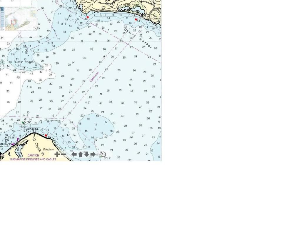
          RED DOT - 600 foot long heavy duty dock


          RED DOT - 600 foot long dock
          YELLOW DOT - Mansion with bunker
          BLUE DOT - Lookout Tower Building with bunker


          RED DOT - 600 foot long dock ( 41 5' 30.63"N, 72 7' 03.98"W )
          GREEN DOT - Power house near historic Windmill


          RED DOT - 600 foot long dock ( 41 05' 29.64"N, 72 08' 19.06"W )


          The power supply end located on Long Island is really near "Camp Fireplace" originally a US Navy military base which today is a "Girls Summer Camp" with some ruins remaining.

          RED DOT - 600 foot long dock ( 41 03' 07.71"N, 72 09' 19.31"W )
          PINK DOT - Camp Fireplace


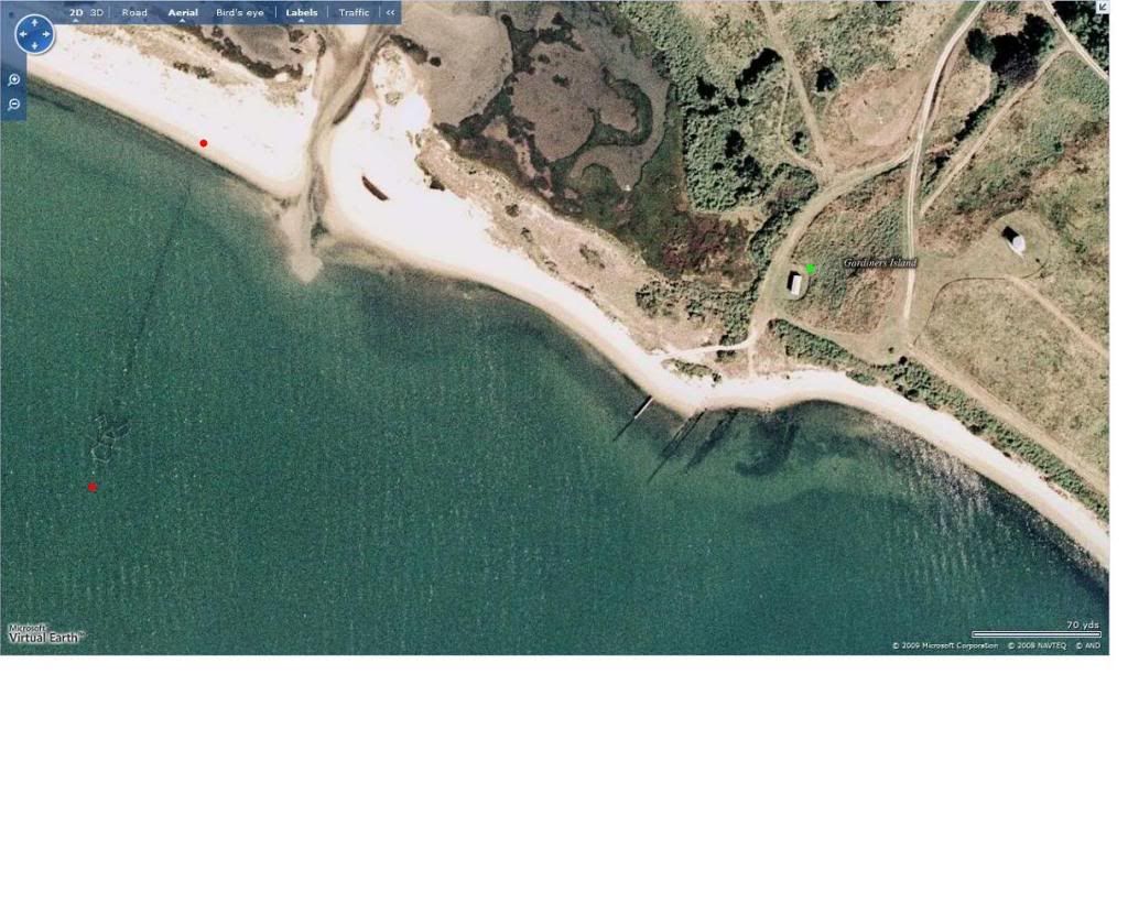
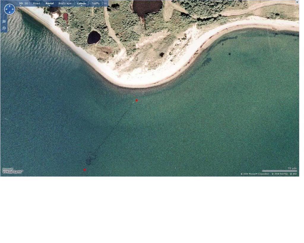
          FYI, those are absolutely not docks, and they are far from "heavy duty".

          Comment


          • Originally posted by wedged View Post
            FYI, those are absolutely not docks, and they are far from "heavy duty".
            Hi wedged,

            Welcome to Energetic Forum, I see this is your first positing here and possibly haven't got to any later threads with addition information on ......

            http://www.energeticforum.com/50759-post186.html

            As for the 70 year old docks I understand what your saying but .... I didn't go into the eight other 600 foot long docks found that seven are within 500 - 1000 feet of a railroad track or roads for delivering ammo and fuel .....

            41 02' 31.67"N, 71 51' 56.23"W Fort Pond Bay
            41 02' 28.44"N, 71 58' 07.34"W "
            41 02' 31.98"N, 71 58' 28.98"W "
            41 02' 21.80"N, 72 00' 05.90"W Napeague Bay
            41 01' 51.74"N, 72 00' 39.36"W "
            41 01' 43.12"N, 72 00' 50.31"W "
            41 01' 20.40"N, 72 01' 24.90"W "
            40 59' 49.07"N, 72 06' 41.71"W
            These are in known documented dock areas used for loading supplies and cargo in WW1 and WW11 located next to the RR tracks at military facility's in bay areas, not in the main waterways for ocean wave control ............ are you sure, because you would be the very first person to claim different since the time of the posting in April ??

            And thanks for the input,

            Regards,
            Glen
            Open Source Experimentalist
            Open Source Research and Development

            Comment


            • I am 100% positive that the pictures I quoted are not pictures of docks of any sort. I put the other coordinates that you supplied into google maps and it's locating them much further offshore, with nothing of significance nearby. Can you post pictures/screen grabs of the 8 other coordinates for docks ?

              As far as an underwater power cable covering the 2.5 miles from the main land to Gardeners Island, why is that a big deal ? The power is supplied to Plum Island in the same manner, just a shorter distance. Plum Island was (still is?) equipped with generators, but Plum Island is totally different subject in itself...

              Comment


              • Originally posted by wedged View Post
                I am 100% positive that the pictures I quoted are not pictures of docks of any sort. I put the other coordinates that you supplied into google maps and it's locating them much further offshore, with nothing of significance nearby. Can you post pictures/screen grabs of the 8 other coordinates for docks ?

                As far as an underwater power cable covering the 2.5 miles from the main land to Gardeners Island, why is that a big deal ? The power is supplied to Plum Island in the same manner, just a shorter distance. Plum Island was (still is?) equipped with generators, but Plum Island is totally different subject in itself...
                Hi wedged,

                I guess "technically" speaking your right, yes they are not a complete usable functioning dock by no means, but the thousands of wooden pilings left from docks that are "underwater" only visable at "low tide". I estimate the docks were approxemently 20 feet wide and 600 feet long, installed around 70 years ago, your viewing images from a minimum of 700 to 1000 feet above Earth, the coordinates shown are from "Google Earth" and all the locations can only be seen using "Microsoft Virtual Earth" maps Microsoft Virtual Earth because of the angle of the sun and possibly the images were taken in early spring or late fall when the water is colder as you can see the Long Island Sound bottom is visible in areas. Also you should be able to see the "Microsoft" watermarks on each satellite images that were used. You'll have to toggle between "Google Earth" and "Microsoft" and they will be very very easy to see.

                If you read most of the "Tesla's Wireless Electricity Transmission" postings the entire end of Long Island and Montauk was nothing but various military bases from WW1 and WW11 and very few buildings exist today, most all removed by the government and the land mostly used now are for State or County Parks all of the Long Island Railroad easements used by the military are still there and visible but are now bike and nature trails.

                The underwater power issue yes I can understand why Plum Island also known as "Fort Terry", "Fort Michie" and "Fort Wright" all long time military bases had each separate shore power, but the oldest privately owned Island in the United States "Gardiner Island" with a 2.5 mile underwater shore power, the family at the time and still even today with huge financial difficulties being able to foot the cost of this luxury, were talking "big big bucks" here for several homes and some outbuildings. The fact that the US government was ever there and with the "fly over" restrictions for around 50 years it wasn't for the beautiful view and the exotic plants and wildlife there ..... the government came they left nothing visible there (slash and burn), just like they did at all the other military bases on Long Island and Montauk.

                I do know how sensitive Gardnier Island is and how the present owner has a agreement with New Your State until 2020 and at that time some sub dividing of the land for sale could be possible, but hopefully this will never happen.

                Have fun looking I've spent months and there's a lot to see .......

                Regards,
                Glen
                Open Source Experimentalist
                Open Source Research and Development

                Comment


                • The pilings have not been in place for 70 years. The pilings are not even in place for an entire year at a time, only several months at a time, 6-8 months at most. The maximum width of the long section coming out from the beach is no more than about 12" wide and never has been any wider. You can find more of these temporary structures in other shallow areas along the shoreline if you look over aerial pictures from the mid 1980's and older, but they have to be pictures from warmer months. I'll try to see if I can find any for you. I know the former location of several more of these structures. There were 2 in Shelter Island Sound/Southold Bay on the North side of Reydon shores. One was offshore of Oak Drive and the other was bit more to the east. There were also some of them in Orient Harbor on the North side of the sand spit with the light house at the Western end.


                  Also, if you take a look at the current google maps you'll notice no sign at all of the structures near Cherry Hill Pond or Fireplace Lodge or to the North of where the underwater power lines are located near the shallow creek that was dry in the other pictures. You'll note that these current pictures are from the late fall/winter or very early spring as there are no leaves on the trees.


                  I just realized that i did not intend to include the last photo of Springs Rd/Hog Creek Lane in the photos above that I quoted. Sorry.
                  Last edited by wedged; 07-23-2009, 08:41 PM. Reason: additional info

                  Comment


                  • On 7/24/09 I got confirmation that there is at least one of these structures currently in place on the East side of Gardeners Island.

                    Comment


                    • Originally posted by wedged View Post
                      On 7/24/09 I got confirmation that there is at least one of these structures currently in place on the East side of Gardeners Island.
                      Hi wedged,

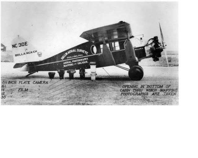
                      Thats good news, it's to bad that at the time I posted the information there wasn't any 1938 Aerial Photographs available. I understand back in the middle 1930's to 1940 there was a program to photograph both coast lines of the United States with major cities and military installations by the Department of the Interior. They used high flying air planes with some strange cameras taking what are some fairly good pictures, here are some of the fellows and equipment used for this large task.


                      1938 Aerial Photographs of Suffolk County, N.Y.

                      This is a valuable asset the Quadrangle 1938 Aerial Photographs of Suffolk County, N.Y. for any Navy bases Tesla may have been at installing his radio equipment or possibly 50 percent of experiments that were done on Long Island for various entities, some disclose some not.

                      You will notice that Gardiner Island East, New London, Mystic and only part of Plumb Island (Plum Island Masked by Google Earth) are missing from the Listings at the Stonybrook files, you'll notice that this is common for maps and photos to disappear around any sensitive "military sites", another being Colorado Springs, Colorado where Teslas first "wireless electrical transmission" area was and home of one of our most important military sites those are missing also.

                      There are "aerial maps" of areas that can be very useful, the ones listed pertain to coastal or specific inland sites -

                      Bay Shore East
                      1-21

                      Bellport
                      5-22, 5-24, 5-26, 5-28, 5-30

                      Central Islip
                      6-61

                      East Hampton
                      4-81
                      3-24, 3-22, 3-20, 3-18
                      2-75, 2-77, 2-79, 2-81
                      1-76

                      Eastport
                      2-48

                      Gardiners Island East
                      4-44, 4-42, 4-40, 4-36

                      Gardiners Island West
                      4-96, 4-94, 4-92, 4-90
                      4-81, 4-83, 4-85, 4-87
                      3-20, 3-18, 3-16

                      Greenport
                      5-67, 5-69,
                      4-79, 4-81

                      Howells Point
                      1-27

                      Lloyd Harbor
                      7-18

                      Mattituck
                      8-57
                      6-22, 6-24, 6-21, 6-19, 6-17
                      5-49, 5-51, 5-53, 5-55, 5-57
                      4-61, 4-63, 4-65
                      3-47, 3-45, 3-44, 3-42, 3-40
                      2-58

                      Mattituck Hills
                      8-57,
                      6-21, 6-19, 6-17

                      Middle Island
                      7-70, 7-72, 7-74
                      8-30, 8-32, 8-34, 8-36, 8-37
                      6-53, 6-51, 6-49, 6-47, 6-45, 6-44
                      5-24, 5-26, 5-28, 5-30, 4-36

                      Montauk Point
                      2-93, 2-91, 2-89, 2-87
                      3-9, 3-7, 3-6, 3-4, 3-2

                      Napeague Beach
                      3-16, 3-14, 3-13
                      2-81, 2-83, 2-85

                      Northport
                      7-18

                      Orient
                      8-85
                      9-1, ,9-3

                      Patchogue
                      6-61, 6-59, 6-57, 6-55
                      5-22
                      2-22, 2-24, 2-26

                      Plum Island
                      9-1, 9-3
                      8-76

                      Port Jefferson
                      7-39
                      7-34, 7-32, 7-30, 7-28
                      7-64, 7-66, 7-70
                      8-22, 8-24, 8-26, 8-28, 8-30
                      6-61, 6-59, 6-57, 6-55, 6-53

                      Quogue
                      2-58

                      Riverhead
                      8-46, 8-48
                      6-36, 6-34, 6-32, 6-30
                      5-41, 5-43, 5-45, 5-47
                      4-54, 4-56, 4-57, 4-59, 4-61
                      3-54, 3-53, 3-51, 3-49

                      Sag Harbor
                      5-67, 5-69
                      4-75, 4-77, 4-79, 4-81
                      3-23, 3-25, 3-27, 3-29, 3-24
                      2-66, 2-68, 2-70, 2-72, 2-74
                      1-67, 1-69, 1-71, 1-73, 1-75

                      Saint James
                      7-39, 7-34, 7-64
                      8-22

                      Sayville
                      2-22, 2-24, 2-26
                      1-21, 1-23, 1-25, 1-27, 1-28

                      Shinnecock Inlet
                      1-67

                      Southampton
                      6-17,
                      5-57
                      3-40
                      2-66
                      1-67

                      Southold
                      6-17

                      Wading River
                      4-48, 4-50, 4-52, 4-54
                      6-44
                      7-46, 7-74
                      8-37

                      Of course these aerial images was before the "Lend Lease Act" president F.D. Roosevelt signed in March 11, 1941 when we started supplying large quantities of ships to European Countries for WW11. The New York and New Jersey shipyards were producing at a average of one complete "hull" daily and they were transported to military bases in the Long Island Sound for final fitting of each ship (electrical, electronics, guns, ammo, supplies, fuel, crews, testing ... etc.) this would include any 300 foot class "DE" battleships (Philadelphia Experiment ??) also tankers, freighters, cargo carriers, mine sweepers, support ships all needing a place to dock to get ready for sea, going or coming in.

                      The wireless electrical transmission, radio equipment, ocean mine degaussing and submarine RC torpedo testing for the Navy was all done by Tesla in Long Island a really busy place.

                      Happy Hunting !!

                      Regards,
                      Glen
                      Last edited by FuzzyTomCat; 07-25-2009, 11:38 PM. Reason: spelling - grammer
                      Open Source Experimentalist
                      Open Source Research and Development

                      Comment


                      • The structures in the pictures are fish traps.

                        Comment


                        • Originally posted by wedged View Post
                          The structures in the pictures are fish traps.
                          wedged, your saying those are "FISH" traps ..... "fish traps" ..... that's good and original, normally this would draw a "RED" flag to me being on forums for several years, and having someone (a newbie) post only in one thread like you have with no proof of rebuttal information on the topic, so what I'll do for you is contact and send my information with the http:// aerial image links to -
                          -------------------------------------------------------------------------

                          New York State Department of Environmental Conservation
                          625 Broadway
                          Albany, New York 12233-0001

                          New York State Department of Environmental Conservation

                          Region 1 Program Contact Information
                          SUNY @ Stony Brook
                          50 Circle Road
                          Stony Brook, NY 11790-3409
                          Nassau and Suffolk counties

                          Regional Director
                          Peter Scully
                          Phone Number (631)444-0345
                          Fax Number (631)444-0349

                          Bureau of Marine Resources - NYS Dept. of Environmental Conservation
                          Marine Resources Headquarters
                          205 North Belle Mead Road
                          Suite 1, East Setauket
                          New York 11733
                          E-mail the Bureau of Marine Resources: fwmarine@gw.dec.state.ny.us

                          Nassau and Suffolk County Permits
                          r1dep@gw.dec.state.ny.us

                          -------------------------------------------------------------------------

                          Being any Commercial Fishing license (or trapping) would have to come from the State of New York, I'll also ask why these "Fish Traps" are in these navigable waterways from land 600 feet in length out, and will post the returned replied information.

                          Regards,
                          Glen
                          Open Source Experimentalist
                          Open Source Research and Development

                          Comment


                          • Calling the DEC (ask for Debra Barnes providing she still works for the DEC) is a great idea, but you may also need to call the local township since it may be out of the DEC's jurisdiction due to the proximity to the shore. It's likely the DEC will know about the traps no matter what. Yes, the traps are permitted and there is a limited number of permits available. The reason I know what they are is because my dad is a commercial fisherman and I've worked with him a few times over the years. I grew up on (not "in" ) Long Island and spent a lot of time on the water. He's done many different things over the years, and one of them was fish trapping. I can remember helping my dad tend to his traps back in the 80's in Southold bay. He's currently trapping conchs in Gardiners Bay and the other day he verfied that at least 1 trap is currently there. As far as being in navigable waters, NOAA issues new charts and updated navigation warnings frequently. They include hazzards such as fish traps and other gear on the bottom that can cause problems. When my dad was doing a clam relay program his clam cages were shown on the charts.

                            For now, this is the best I can do : http://www.nytimes.com/2007/07/07/ny.../07summer.html

                            There's pictures, an article and some video too.

                            Comment


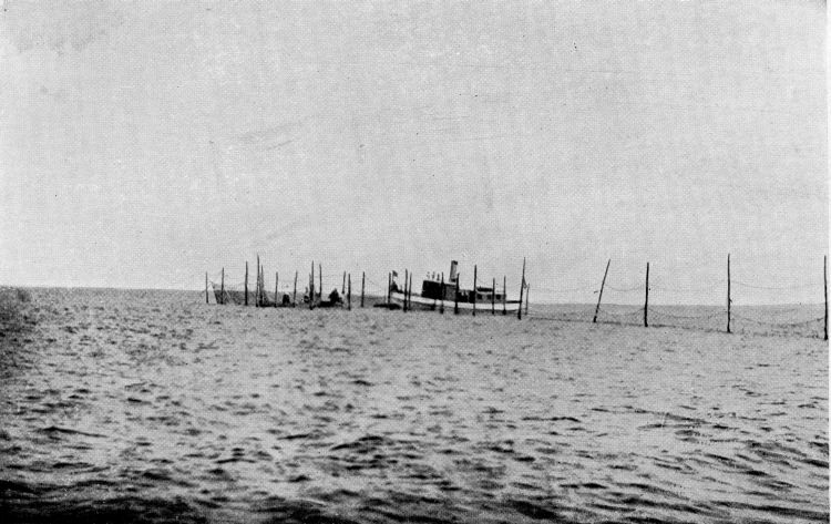
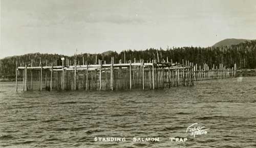
                            • Similar designs have been used around the world for hundreds of years. I found some generic photos, i don't know the locations of all of them.


                              this is Long Island, but a much smaller trap : Fish Trap photo - Chris Thorpe photos at pbase.com

                              This one is from Alaska, similar function, but different design


                              Columbia River Basin


                              Bellingham, WA, 1920's


                              Comment


                              • Because they are not permanant, the fishtraps are not designated on all charts, but they are referenced on many. Toward the bottom left of page 3 of the Bookletchart link below you'll see the symbol for a fish trap area is a long dash and a short dash in pink with a warning of potential submerged pilings. When you look the chart over, you'll find that almost all land masses are surrounded by the pink short dash long dash.

                                NOAA BookletChart


                                Part of the reason that the 1938 photos may be missing from the Gardiners Island area is because an area just to the North, called the ruins on maps, was used for practice bombing runs. It's still designated as a hazzardous area and you're not supposed to anchor there. There may still be unexploded bombs. I only scuba dived that area one time with a buddy, but we didn't see anything that looked like bomb remnants.

                                As you've already discovered a whole lot of Long Island as well as parts of Connecticut were used by some branch of the government over the years either directly or indirectly. Groton Ct-Electric Boat Company, Plum Island Animal Disease Reserch (my grandfather worked there), Brookhaven National Lab, Westhampton Air National Guard base, Grumman facilites at Calverton (dad worked there before becoming a fisherman) Valley Stream, Farmingdale and Bethpage, the first submarine base was in New Suffolk, just a few miles to the west of Gardiners Island, the list is almost endless. In my early teens, my friends and I were all through the old building of the New Suffolk Sub base before it was demo'd. It was pretty much an empty wood shell at that point.
                                Last edited by wedged; 07-26-2009, 04:39 PM.

                                Comment

                                Working...
                                X