Announcement

Collapse
No announcement yet.

Tesla's wireless electricity transmission

Collapse
X
 
  • Filter
  • Time
  • Show
Clear All
new posts

  • Hi wedged,
    Thank you for the links and photos for reference, as your self I also am familiar with boating in between my EE carrier and my Electrical contracting I was captain of a Luxury Yacht rental service and also had a small 31 foot Pearson sail boat. I live 20 blocks form one of the worlds longest rivers that runs from south to north called the Willamette River which empties into the Columbia River this river is known to have one of the most dangerous bars in the world and fishing widely known . I've done charters up and down both rivers from the mouth of the Columbia to the Tri Citys area in Washington 100's of miles and the Willamette for several years. The photos you referenced of the fish traps in Oregon and Washington are from 1905 to around late 1930's and this type of fishing here including the Keegan's Trap Net has been done away with decades ago, the only peoples that have different rights are the Indian tribes along the two rivers.

    Thats why I'll make the contacts to the New York State Department of Environmental Conservation I suggested, to try to verify this as the US Government Departments has only given me a run around over and over on several important questions that have been raised by my findings, and this is one of them. If you cross check the coordinates the now mystery images are almost "exactly" where some type of military function was happening years ago, to many coincidences.

    The same type of boat building was going on during WW11 in the Columbia river in Portland, Oregon and Vancouver, Washington the ships were transfered to Camp Rilea out side of Astoria for final fitting and crews part of the the Pacific Fleet. I saw the docks 45 years ago at Camp Rilea because this is where they moth balled 100's of ships after the War for decommissioning and scraping and the docks were shaped the same as the mystery figures now in question.

    I also did a posting here on Plum Island http://www.energeticforum.com/52657-post16.html spooky place ......

    Regards,
    Glen
    Open Source Experimentalist
    Open Source Research and Development

    Comment


    • Yeah, Plum Island is weird. My grandfather was a heavy equipment operator there in the 70's and early 80's. I wish I could have asked him more about what he saw or heard was happening there, but he died in the mid 80's. I actually found this forum through a photo link of the ruins in this thread. My mom has Lyme disease and lots of people are wondering if there is any connection to Plum Island. You need to read Lab 257 by Michael C. Carroll. Freaky scary stuff.

      If you want to avoid some bureaucratic bs you can try contacting the Cornell University Co-operative extension Marine Program. They do a lot of work with the local fisherman and should be able to give you some info. In fact, I just remembered that there used to be a fish trap directly off shore east of their facility at Cedar Beach in Southold, my old home town. It was literally about 1000' from their building. I am pretty sure there was a second one near there, about 1/2 mile to the north.
      Last edited by wedged; 07-26-2009, 08:05 PM.

      Comment


      • Underwater Structures

        Hi everyone,

        As I referred to earlyer with questions on the images by Energetic's member "wedged" possibly being fish traps and now I have found out additional information on the eleven (11) underwater structures I refer to as WW11 docks approxemently 600 feet long appearing all constructed the same, photographed by satellite the same day probably the same pass over.

        41 05' 29.64"N, 72 08' 19.07"W (Gardiner Island) [1]
        41 05' 30.61"N, 72 07' 03.95"W "
        41 03' 07.70"N, 72 09' 19.29"W (Fire Place Camp)
        40 59' 49.00"N, 72 06' 41.31"W
        41 01' 20.36"N, 72 01' 24.72"W (Fort Pond Bay - Flaggy Point) [2]
        41 01' 43.08"N, 72 00' 50.17"W "
        41 01' 51.72"N, 72 00' 39.21"W "
        41 02' 21.74"N, 72 00' 05.81"W (Napeague Bay)
        41 02' 31.99"N, 71 58' 28.90"W "
        41 02' 28.40"N, 71 58' 07.22"W "
        41 02' 31.64"N, 71 57' 56.11 W

        [1] Google Earth visable at 1700 feet
        [2] Google Earth visable at 6100 feet

        The first response is from -
        ---------------------------------------------------------------------

        Laura B. Stephenson
        Peconic Estuary Program Coordinator
        NYSDEC, Bureau of Marine Resources
        205 N Belle Meade Road, Suite 1
        East Setauket, NY 11733
        Tel: 631.444.0871
        Fax: 631.444.0474
        lbstephe@gw.dec.state.ny.us

        Good morning, Glen!

        While the Peconic Estuary (the body of water between the north and south forks of Suffolk County, Long Island, NY) is my area of focus, and I am quite familiar with those East End waters, I unfortunately do not have any information on these seemingly past erected structures. The East End has a very long and fascinating history, and think that you may make more progress tapping into local knowledge. I might suggest contacting the East Hampton Historical Society ( East Hampton Historical Society - ) or maybe even the East Hampton Trustees ( East Hampton Trustees - The Trustees of the Freeholders and Commonalty of the Town of East Hampton ) who actually govern all activities/structures/uses on/of underwater lands. They may have some useful information on the structures and prior uses of abutting lands. My other thought would be to ask the Navy directly.

        Apologies if I have not been helpful, but perhaps I have pointed you in a better direction.

        Regards,
        Laura

        ---------------------------------------------------------------------

        The second very short on records of commercial fishing liscences for any use in the eleven questioned areas ....

        ---------------------------------------------------------------------

        Sorry, we do not keep information of this nature on file.

        Mark Carrara
        Deputy Permit Administrator
        NYSDEC Region 1
        631-444-0374

        ---------------------------------------------------------------------

        I have now contacted the orginazations that Laura B. Stephenson, Peconic Estuary Program Coordinator suggested and awaiting a response, I did at one time ask the Navy but that was months ago ...... I'll try now again with this additional information coming in.

        Best Regards,
        Glen
        Last edited by FuzzyTomCat; 08-04-2009, 09:36 PM. Reason: updated latitudes and longitudes to new "Google Earth" version
        Open Source Experimentalist
        Open Source Research and Development

        Comment


        • Glen, get in touch with the people at Cornell, they may be of more help. Did you try to contact Debra Barnes at the DEC ? I would contact them for you, but I do not want to be accused of making stuff up. Like I said, I know for a fact that it is a fish trap and this is because I am local to the area and there were many fish traps. Did you read the NY Times article and look at the pictures ? You can clearly see the polygon shape of the net - that portion of the trap is called the "pound" and thats where the traps get their name- "pound traps" - that is visible in the aerial photos. I would ask my dad to take pictures of the trap on the east side of Gardener's Island, but when he's working, he's working. If I still lived there, I'd go take the pictures myself.

          Comment


          • @ wedged

            Originally posted by wedged View Post
            Glen, get in touch with the people at Cornell, they may be of more help. Did you try to contact Debra Barnes at the DEC ? I would contact them for you, but I do not want to be accused of making stuff up. Like I said, I know for a fact that it is a fish trap and this is because I am local to the area and there were many fish traps. Did you read the NY Times article and look at the pictures ? You can clearly see the polygon shape of the net - that portion of the trap is called the "pound" and thats where the traps get their name- "pound traps" - that is visible in the aerial photos. I would ask my dad to take pictures of the trap on the east side of Gardener's Island, but when he's working, he's working. If I still lived there, I'd go take the pictures myself.
            Hi wedged,
            I have sent out e-mails to Cornell and haven't heard back yet from them and when sending out the e-mail to Debra Barnes Department at the DEC it must have been referred to Laura B. Stephenson.

            I think that the explanation of these images being a fish trap although very similar in nature and located in proximity to these areas has one big problem that everyone contacted including myself has is the "size" issue in all aspects. I would say and most could agree over 6600 feet of fish trap nets is quite a bit for any small operation to check daily and would have to be a large commercial operation and with no information on file from Mark Carrara, Deputy Permit Administrator, NYSDEC Region 1, this to me is perplexing.

            The other problem is all the images I have noted are all visible with Microsoft Virtual Earth but there are also two that can be seen using "Google Earth" taken with a different satellite and year and submerged.
            41 05' 29.64"N, 72 08' 19.07"W (Gardiner Island) [1]
            41 01' 20.36"N, 72 01' 24.72"W ("Flaggy Hole" well known Military site) [2]
            [1] Google Earth visable at 1700 feet
            [2] Google Earth visable at 6100 feet

            The "size" issue for example is looking at the "NY Times" Fishing Fades Where All That Glitters Is Sea article you reference in the photograph http://graphics8.nytimes.com/images/..._spread600.jpg the fish trap poles used in the background ..... now imagine looking at them 800 - 1000 feet away ... how big would those poles visually be ?

            Also I do find it very comforting that you indeed are a locale, and it does hold a lot of weight with me and possibly others, this is very valuable for all forum members to have someone familiar with the stomping grounds (Long Island NY, Suffolk County) of the hands down greatest inventor of all time Nikola Tesla. I would think any help you may provide us would be well received, all we could ask is to closely document and retain all pertinent information if questions arrive on the validity of what ends up being posted, only fair.

            Check your PM ....

            Best Regards,
            Glen
            Last edited by FuzzyTomCat; 08-04-2009, 09:40 PM. Reason: updated latitude and longitude to new "Google Earth" version
            Open Source Experimentalist
            Open Source Research and Development

            Comment


            • The length of the leader (part perpendicular to the shore line) being 600' is a bit on the long side for this type of trap. The ones my dad had were not that long, maybe 200'-300' , but his were in a smaller bay. The pound area being about 40'-50' across. They are easy to tend with a small boat. In fact you have to have a small boat to tend them. My dad used 2 boats to do this. One larger boat for the catch, and a 10'-12' garvey or dingy to tend the nets. A lot of times the tender did not even have a motor or oars. Just hang onto the netting and move yourself around. My dad and a partner tended 4-5 of these traps. It's not a big deal nor does it take a big operation to do it.

              The apparent width of the leader can be deceiving when photographed from above, due to shadows. Once in while the nets need to be cleaned. The way to do that is to lift it out of the water, bunch it up over the lines that connect the posts and let i dry for a few days or so. This bunched up netting would create a much bigger shadow if not illuminated from directly above and if there was any angle of the camera when the photo was taken. I know, it sounds far fetched, but when i was looking for pics, i found one that i could tell that the net was being cleaned & dried. I don't know which one it is or if i can find it again. The tidal current in this area is a lot less than it would be in a river and this is why the leader can be so much longer- less stress on the poles and net.

              I will have to break down and download google earth and virtual earth to look at the other locations since I have not done that yet.

              Comment


              • Ok, i looked at each of those coordinates and they are all fish traps. I found something that you may want to see. Go to 41 02' 31.64"N, 71 57' 56.11 W on Bing maps. You will see the intersection of Navey Rd and Shore Rd with a trap right off the end of Shore Rd. Now go to the same spot on Google maps. They are calling it Navy Rd and Second Home Rd....

                here's the kicker... you can see the tire tracks on the beach al around a trailer that is still on the beach. The trailer has a load of fish trap stakes on it. There are also a few small flat bottom boats on the beach. There's also nothing visible in the water where the fish trap was in the Bing map. Follow the shore line along to the "west" on both maps. You'll see the traps there on Bing, and nothing on Google.


                Remember back on 7/23 I mentioned there were some on the North side of the sand spit in Orient Harbor ? Visble in Bing Map at 41.127&N 72.3244W . That one is interesting to me, since it's a double trap.

                Comment


                • Ok, now it's geting fun. 41.0764 N 72.3907 W . That's only about 1.5 miles from where my house was. Been past there on a boat dozens of times. That one is really good in Bing because you can actually rotate the image and see the stakes from the side. It doesn't look like it has nets on it yet, just the lines from stake to stake. Make sure you toggle between birds eye and aerial.

                  Here's one I used to anchor by when out on my boat 41.0498 N 72.3943 W Visible in aerial, but not in birds eye.

                  Here's one along the Eastr side of Jessups Point : 41.0155 N 72.3718 W

                  This one is hard to see 41.0098 N 72.3677 W

                  41.0072 N 72.3187 W

                  41.0466 N 72.224 W

                  41.0421 N 72.1786 W

                  41.0547 N 72.2737 W

                  41.0454 N 72.3310 W

                  41.0302 N 72.2822 W

                  Comment


                  • Originally posted by wedged View Post
                    Ok, i looked at each of those coordinates and they are all fish traps. I found something that you may want to see. Go to 41 02' 31.64"N, 71 57' 56.11 W on Bing maps. You will see the intersection of Navey Rd and Shore Rd with a trap right off the end of Shore Rd. Now go to the same spot on Google maps. They are calling it Navy Rd and Second Home Rd....

                    here's the kicker... you can see the tire tracks on the beach al around a trailer that is still on the beach. The trailer has a load of fish trap stakes on it. There are also a few small flat bottom boats on the beach. There's also nothing visible in the water where the fish trap was in the Bing map. Follow the shore line along to the "west" on both maps. You'll see the traps there on Bing, and nothing on Google.


                    Remember back on 7/23 I mentioned there were some on the North side of the sand spit in Orient Harbor ? Visble in Bing Map at 41.127&N 72.3244W . That one is interesting to me, since it's a double trap.
                    It appears your correct on the one located at the Navy Rd and Second Home Rd....the last one on the list, .... Hummm .... kind'a funny the Deputy Permit Administrator of NYSDEC Region 1, didn't catch it.

                    The satellite images I was most concerned with was Gardiner Island, Fire Place Lodge Girls Camp and Flaggy Hole Images posted that are at least 600 feet long and the one at 41 01' 20.36"N, 72 01' 24.72"W ("Flaggy Hole" well known Military site) that can be seen using Google Earth above 6100 - 6900 feet, thats really high up there. I think those images were the first listed I first talked about and included the last 6 to 8 sites in a later posting for a total of 11 sites.

                    So I guess agreeing with highest probability your correct on the least two, for sure the ones near the trailer holding poles and the tire tracks between ..... kind'a funny, nice work.

                    I'm interested to see what the rest of my inquires have to say ...

                    Best Regard's
                    Glen
                    Open Source Experimentalist
                    Open Source Research and Development

                    Comment


                    • New revision of Colorado Springs Notes?

                      While searching the internet I came across a website called Tesla Universe, which includes a list of book about Nikola Tesla and his work. It appears that a new extended edition has been recently published by the Nikola Tesla Museum called "From Colorado Springs to Long Island" which is described as a complete version of the Colorado Springs Notes with the addition of never before published notes written in New York after his time at Colorado Springs. Here is a link to the Tesla Universe page describing the book:

                      Nikola Tesla - From Colorado to Long Island: Research Notes - Colorado Springs 1899-1900 - New York 1900-1901

                      I was unable to locate the book at Amazon; the Nikola Tesla Museum online store seems to be under construction.

                      Comment


                      • UPDATE: "Nikola Tesla - From Colorado to Long Island: Research Notes" is now available at Twenty First Century Books. However, it is quite expensive at $185.00. The book contains construction details of Wardenclyffe Tower:

                        Nikola Tesla—Colorado Springs to Long Island, 1899-1900, 1900-1901 | ISBN-13: 978-86-81243-44-2

                        Comment


                        • question?

                          I have a question for anyone who might have the answer. Does anyone know what frequency tesla was planning on using for his wireless power transmission. He states in his magnifing transmitter patent that it is desirable to have a high frequency and high voltage, how low of a frequency could be used and still get good results? Having a high frequency and high voltage poses some perplexing difficulties. To get the highest voltage you need many turns of wire on the secondary, but the more turns you use the lower the resonant frequency gets. So i guess in order to keep the number of turns down and the frequency up you need to input the highest voltage possible on the primary to begin with. I see why tesla spent so much time working on these issues. Anyways, how low is too low, does anyone know?

                          Comment


                          • Many of your questions and a real glimpse of Tesla technology and methodology can be answered by reading Colorado Spring Notes.
                            ...

                            In our subject, Tesla planned at sending energy via the ground to the whole planet and the reception would be made by a Tuned tesla coil to the ground signal.

                            Frequency should be high enough to be able to transmit enough power, but low enough so as to have EM losses to a minimum (they increse with frequency)
                            20Khz is typically suggested at the patent.

                            But as it is known, Tesla discovered that energy propagation via ground is far more enhanced at particular freuqncies that the earth "responds" or resonates. That means minimum losses.

                            Tesla has claimed that he could send energy at industrial levels to whatever part of the earth with an efficiency of 97-98% whereas modern method of energy transfer range from 60-70% eff. with heavy infrastructure investments.

                            We have not concrete evidence that actually Tesla could do that. In any case assuming he could, there is the other big issue of energy management.
                            Each one could steal that transmited energy via ground no matter where on the globe is land or sea.

                            This is a real pain indeed.

                            Comment


                            • Thanks for the reply. May i ask where you got 20kHz from? I will have to read his lab notes, good idea. In working in tune with the earth would you say that it should be more efficient to operate on an octave of the schuman resonant point? I had been planning on trying a octave of it but have not herd anyone actually confirming that there is any advantage. I find it interesting that the schuman point is remarkably close to the music note B and so is 60Hz at a higher octave. Would that be what is called decibel tunning? I have herd tesla tuned to frequency and decibel but i never understood what that meant.

                              thanks
                              cody

                              Comment


                              • Hi Glen,


                                I'm new to this group. The statement in this forum about Telsa in the fall of 1899 did his "Electrical Transmission" experiment and lit 200 inductive lamps around 26 miles away in Larkspur is a historic event. Did you find this information in one of the local newspapers of the times?

                                Bob


                                Originally posted by FuzzyTomCat View Post
                                Hi All,

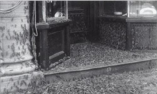
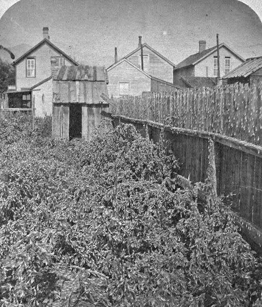
                                There is one tasty bit of information that has been discussed but over looked through the years, it's about grasshoppers. During the 1800's the "mesa" in Colorado Springs was infested with grasshoppers billions of them this is probably why the ancient Indian dwellers of the area went to the cliffs or left.

                                The grasshoppers would show up around the middle of April to May and stay around for four months eating everything in sight estimated 10 to 100 acres a day. It got so bad in 1885 that the governor of Colorado went to congress for help and got none, in 1899 it was the worse it had ever been more like a plague.


                                In the fall of 1899 is when Tesla did his "Electrical Transmission" experiment when he lighted 200 inductive lamps around 26 miles away in Larkspur or Palmer Lake, this was the night when the ground glowed around the Colorado Springs laboratory like "saint elmos fire" and sparks would jump from the ground to your feet when you were walking.

                                In the spring after Tesla left in 1900 the "Grasshoppers" were gone well almost they found one and the "Colorado Beetle" or common potato-bug was gone also. The grasshoppers were never to return again to the "mesa" of Colorado Springs ....

                                Glen

                                Comment

                                Working...
                                X